
 |
| Mayan directions |
What do the Book of Mormon authors mean when they use directions (North, South, East, West) in the text?
If they mean the cardinal directions as we know them today, the Mesoamerican theory is basically impossible. Consequently, John Sorenson theorized that the BoM authors based their cardinal directions on the coastline. In Israel, the Mediterranean coast runs north/south, with the sea on the west and the land on the east, so any sense of direction based on the coast agrees with what we moderns know as the cardinal directions. In other cultures, a reference to a coastline would not line up with the directions on a compass.
Or, as Deane Matheny explained it (as quoted by Brant Gardner):
The most fundamental geographical problem associated with Sorenson’s model has to do with issues of directionality. . . . In order for his model to fit the geography of Mesoamerica, one must assume that the Nephites had a system of directions with cardinal directions skewed “45 degrees or more” off of the usually observed cardinals. . . . In other words, the whole directional card must be shifted more than 60 degrees to the west for this model to fit the geography of the chosen area. Otherwise, as Vogel has pointed out, the land north will be on the west, and the south on the east, and so forth. . . . Making this shift in directions creates its own set of problems, however, because in such a Nephite directional system the sun would come up in the south and set in the north.3
Vogel is far from the only critic to point out this fundamental problem; it's a favorite of anti-Mormon critics generally, as well as a target for faithful LDS who reject the Mesoamerican theory.
Another theory advanced by Brant Gardner takes a more cultural/linguistic approach. Here's how he summarizes it:
I propose that if Mesoamerica is a good fit for the Book of Mormon’s real world geography, then information about Mesoamerica may be used to reexamine and refine the nature of that fit.5 In short, an understanding of the Mesoamerican directional system offers an explanation for the way that Book of Mormon directions correspond to that geography, without recourse to an artificial shift in the directions.
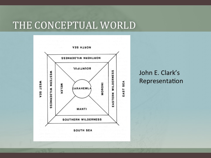
Gardner offers a detailed and well-reasoned explanation of the Mayan system which leaves the issue of directions far more fluid than one would expect by simply reading the text. Basically, he suggests the Mayans viewed directions as quadrants:
There was no “north” in the Mesoamerican system–only a spatial relationship to that side of the sun’s path. That is why the vocabulary varies so greatly. It wasn’t that Mesoamericans didn’t know where north was, they conceived it entirely differently. It existed only as a quadrant on the right or left of the sun’s path—where some Mesoamerican cultures called it “right” and some “left.”
He notes this about the Hebrew concept:
William J. Hamblin, professor of History at Brigham Young University notes: The Hebrews, like most Semitic peoples, oriented themselves by facing east, toward the rising sun. Thus east in Hebrew was simply front (qedem), with south as right (yamîn), north as left (śemôl), and west as rear (achôr) or “sea” (yam). . . .
My take on Gardner's thesis boils down to this: he's trying to reconcile the fact that the plain text of the Book of Mormon contradicts the Mesoamerican theory. This leads him to superimpose the Mayan concept of directions onto Joseph Smith's translation, so that, as Matheny explained, the term "north" in the Book of Mormon doesn't mean "north" but another vague direction, anywhere in the quadrant (the breadth of which varies depending on the time of year) that is before your face if your left arm is pointed at the setting sun.This leads him to this conclusion:
Combined with the differences in terminology and cultural perceptions, it is little wonder that the Book of Mormon directions appear difficult fit onto a modern map. That inherent difficulty becomes even greater when we insist upon reading literal geographic statements where the text does not intend a literal reading. That is the issue that clouds our understanding of the Nephite seas.
He proceeds to discuss how the concept of seas in cardinal directions could be metaphorical, and how the references to a "sea east" could have meant two different seas, based on the frame of reference (Land of Nephi vs. Bountiful).
This opens possibilities very wide indeed.
I'm led to wonder whether this approach undermines any effort to "map" the Book of Mormon, whether in Mesoamerica or North America. We don't know, specifically, how the Hopewell civilization perceived directions. Maybe they adopted an approach similar to the Mayans. Would the Nephites have retained the Hebrew understanding of directions? Would Mormon, having seen our day, use a system of cardinal directions that we wouldn't understand (until Brant Gardner figured it out)?
I think Gardner has gone a long way toward addressing the problem of directions in the Mesoamerican theory, but in so doing, he has introduced another layer of uncertainty into the text. Is this akin to the "modern expansion of an ancient text" approach that undermines the reliability (and credibility) of the Book of Mormon? He sees it as additional evidence for the Mesoamerican theory. (Of course, if he reached a different conclusion, he wouldn't have published his paper.)
But another way to look at it is that he has opened up new possibilities for understanding the North American theory as well.
Here is Gardner's conclusion:
Conclusion
The most serious contraindication for Sorenson’s correlation between Mesoamerica and the Book of Mormon has been his shifting of north some 60 degrees to the west. The quality of the correlations with the rest of the geography and cultural data suggest that we look to Mesoamerica to see if the cultural data from the region in which the Book of Mormon took place (according to this correlation) might provide an understanding of what has come to be called “Nephite North” (though it is not a term Sorenson used55). The combination of the Mesoamerican center and the perception of the quadrants as wedges emanating for that center explain how the Book of Mormon “north” might include a region that our cultural predisposition for cardinal directions would not recognize. Combined with the shifting center points from which directions or spatial relationships may be discussed, we have a culturally appropriate understanding the underlying plate text directions that yielded the English translations of north, south, east and west. In addition to explaining the spatial terms, it also provides a cultural underpinning for why the land northward was Desolation and the land southward Bountiful. Sorenson’s geographic correlation not only remains the best supported, but what has been a directional conundrum actually provides further indication that the plate text was written in a region steeped in the Mesoamerican understanding of spatial orientation.
No comments:
Post a Comment